Translate

Thursday, December 19, 2013

Galápagos Islands South America


Galapagos Islands, South America


The Galapagos Islands are a small archipelago of islands belonging to Ecuador in the eastern Pacific Ocean. 


The islands are quite remote and isolated, lying some 1000 km (620 miles) west of the South American continent. The Galapagos archipelago consists of 13 main islands and 6 smaller isles, which together embrace some 50,000 sq km (19,500 sq miles) of ocean. 


The Galápagos archipelago is world-renowned for its unique and fearless wildlife- much of which was inspiration for Charles Darwin's Theory of Natural Selection. The islands are therefore very popular amongst natural historians, both professional and amateur. Giant tortoises, sea lions, penguins, marine iguanas and different bird species can all be seen and approached. The landscape of the islands is relatively barren and volcanic, but beautiful nonetheless. The highest mountain amongst the islands is Volcán Wolf on Isla Isabela, 1707 m (5600ft) high.


The Galápagos were claimed by newly-independent Ecuador in 1832, a mere three years before Darwin's visit on the Beagle. During the 19th and early 20th centuries, the islands were inhabited by very few settlers and were used as a penal colony, the last closing in 1959 when the islands were declared a national park. The Galapagos were subsequently listed as a World Heritage Site in 1978.


Strict controls on tourist access are maintained in an effort to protect the natural habitats and all visitors must be accompanied by a national park-certified naturalist tour guide.


 The Galapagos Islands are:
- Baltra (an airport and military base)
- Bartolome
- Darwin & Wolf
- Espanola
- Fernandina
- Floreana
- Genovesa
- Isabela - the largest island
- Marchena
- North Seymour
- Pinta
- Pinzon
- Rabida
- San Cristobal
- Santa Cruz - the main island and population centre
- Santa Fe
- Santiago
- South Plaza 


Fairy Pools, Isle of Skye, Scotland


Fairy Pools, Isle of Skye, Scotland


If you are backpacking in Scotland generally or are planning a trip to the Isle of Skye then I heartily recommend that you visit the so-called Fairy Pools.


They are just southeast of Glen Brittle Forest and about two miles before you reach Glen Brittle beach itself. I’m not sure anyone really knows why they are called the Fairy Pools but it’s got to be down to how they look, right? 


They are part of a stream running off of the Cuillin mountains, full of vividly coloured pools of often almost still water which are punctuated by busy waterfalls. It’s best to visit on the day after a small rain shower, on a dry day with some cloud cover. 


That way the water levels will be topped up but not too urgent, and the cloud cover will mean that the water’s surface doesn’t reflect too much light – thereby dimming your view of the stunning colours beneath. If you have an IR filter for your camera now is the time to employ it properly to delete those reflections!


Here is some videos from Fairy Pools, Isle of Skye, Scotland


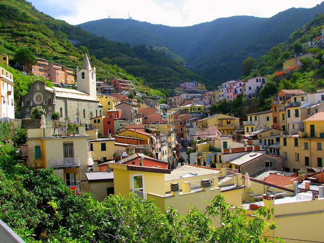
Cinque Terre, Riomaggiore, Italy


Cinque Terre, Riomaggiore, Italy


   Riomaggiore (Rimazùu in the local Ligurian language) is a village and comune in the province of La Spezia, situated in a small valley in the Liguria region of Italy. It is the first of the Cinque Terre one meets when travelling north from La Spezia.


   The village, dating from the early thirteenth century, is known for its historic character and its wine, produced by the town's vineyards. Riomaggiore is in the Riviera di Levante region and has shoreline on the Mediterranean's Gulf of Genoa, with a small beach and a wharf framed by tower houses.


   Riomaggiore's main street is Via Colombo, where numerous restaurants, bars and shops can be found. The Via dell'Amore is a path connecting Riomaggiore to its frazione Manarola, also part of the Cinque Terre.


   Riomaggiore is the most southern village of the five Cinque Terre, all connected by trail. The water and mountainside have been declared national parks.


  Riomaggiore inspired paintings by Telemaco Signorini (1835-1901), one of the artists of the Macchiaioli group.


                                 Here is some videos from Cinque Terre, Rio Maggiore, Italy


LINKS:


Chittorgarh Fort, India


Chittorgarh Fort, India


Chittorgarh Fort has received the credit of being the largest fort of India. The massive fort is located on a high hill near the Gambheri River in Chittorgarh. Chittorgarh Fort lies at a distance of 112 kms from the city of Udaipur in Rajasthan. This fort was built by various Maurya rulers in the 7th century. This huge fort covers an area of 700 acres, extending to 3 kms in length and 13 kms in peripheral length. Standing on an elevated hill of 180m, the impregnable fort has witnessed three battles.


The Fort lastly belonged to the Mewar rulers, whose capital was located there until Mughal Emperor Akbar captured the Fort in 1568. Following this, Marahana Udai Singh II moved the capital to what is now the city of Udaipur. The eldest son of Emperor Akbar, Jehangir, ended up giving the Fort back to the Mewars in 1616. However, they never resettled there.  


Due to its size, the Fort is most comfortably explored by vehicle and it's a good idea to allow at least three hours to do so. Some parts of it are in ruin but its former glory is still very much present. Attractions include old palaces, temples, towers, and a reservoir where it's possible to feed fish. Dramatic views across the Fort and town are offered at the top of Vijay Stambha (Tower of Victory). 


To really understand the Fort's history, attend the evening sound and light show. However, the English version is only shown on Tuesdays and Fridays (it coincides with when the luxury tourist trains stop there).
Chittorgarh Fort can be visited on a day trip or side trip from Udaipur along with Kumbhalgarh, another important fort of the Mewar Dynasty.


Daha Büyük Görüntüle


Here is some videos from Chittorgarh Fort, India


Hiller lake (Pink Lake), Western Australia


Hiller lake (Pink Lake), Western Australia 


Lake Hillier is a pink-colored lake on Middle Island, the largest of the islands and islets that make up the Recherche Archipelago, Western Australia. From above the lake appears a solid bubble gum pink. It is such a significant distinguishing feature of the archipelago that air passengers often crane their necks to take a glimpse of it.
The lake is about 600 meters long, and is surrounded by a rim of sand and a dense woodland of paperbark and eucalyptus trees. A narrow strip of sand dunes covered by vegetation separates it to the north from the Southern Ocean.


Middle Island's pink lake dates back to the journals of explorer Matthew Flinders in 1802. Flinders had climbed Middle Island's highest peak (now known as Flinders Peak) to survey the surrounding waters when he came across the remarkable lake. Middle Island and its pink lake are located in a pristine wilderness. The only way to view this lake is from the air. You can also explore the islands and abundant wildlife of the Recherche Archipelago on a cruise from Esperance.


The reason for the lake’s colour is still under investigation. A possible explanation according to some scientists involves the low nutrient concentrations and different types of bacteria and algae. The pink colouration could also be from a sea salt and nahcolite (sodium bicarbonate) deposit reaction or red halophilic bacteria in the salt crusts.


Daha Büyük Görüntüle


Here is some videos from Hiller lake(pink lake), Western Australia


LINKS:

http://www.australia.com/explore/states/wa/pink-lake.aspx
http://www.amusingplanet.com/2013/03/pink-lake-hillier-in-australia.html
http://www.youtube.com/watch?v=RmpA35AGGvA
http://www.youtube.com/watch?v=tOmf23QDnUY


Petra, Jordan


Petra, Jordan


Petra is a historical and archaeological city in the southern Jordanian governorate of Ma'an, that is famous for its rock-cut architecture and water conduit system. Another name for Petra is the Rose City due to the color of the stone out of which it is carved.


Established possibly as early as 312 BCE as the capital city of the Nabataeans, it is a symbol of Jordan, as well as its most-visited tourist attraction. It lies on the slope of Jebel al-Madhbah (identified by some as the biblical Mount Hor) in a basin among the mountains which form the eastern flank of Arabah (Wadi Araba), the large valley running from the Dead Sea to the Gulf of Aqaba. Petra has been a UNESCO World Heritage Site since 1985.


The site remained unknown to the Western world until 1812, when it was introduced by Swiss explorer Johann Ludwig Burckhardt. It was described as "a rose-red city half as old as time" in a Newdigate Prize-winning poem by John William Burgon. UNESCO has described it as "one of the most precious cultural properties of man's cultural heritage". See: UNESCO Intangible Cultural Heritage Lists. Petra was chosen by the Smithsonian Magazine as one of the "28 Places to See Before You Die."


Daha Büyük Görüntüle


Here is some videos from Petra...


Aogashima Volcano, Japan


     Aogashima Volcano, Japan 


    Aogashima is a small, tropical volcanic island in the Philippine Sea, under the administration of Tokyo despite being located some 358 kilometers away from the country’s capital. It is the southernmost and the most isolated inhabited island of the Izu archipelago. The island itself is a giant volcanic crater, and within that crater there’s another, smaller volcano. Aogashima is still considered an active Class-C volcano though it last erupted in the 1780′s. When last erupted it killed nearly half of the island’s population and forced the remaining inhabitants to flee. It took just fifty years for the people to return. Today, some 200 brave villagers live on the island. 

    The entire population of Aogashima lives on a small part of the island. This is where most of the amenities are located, such as a general store and a helipad. While it’s unrealistic to expect a great night life or gourmet food options in a place as remote as this, Aogashima isn’t totally devoid of activities to pursue. For starters, it is a great place to relax and unwind, basking in all the serenity. Scuba diving is a popular activity in the intensely blue waters. You could also consider hiking and camping by the volcano, or visiting the volcanic hot springs. In the very center of the island is a geothermal sauna. The main volcano has scalding hot steam vents around one side, which are used to power the public sauna – a perfect way to relax after a long day of hiking. You can even cook food at the steam vents, in the pots available outside the sauna to steam your goodies. Accessibility options to and from the island aren’t too great:, as it can only be reached by ferry and by helicopter. Once you’re on the island, you have access to a 24/7 live feed of the harbor, so that you can keep an eye on the weather before venturing out.


    If you are planning on visiting Aogashima , you might want to know that it is actually an active volcano. The last massive eruption was over 200 years ago, in 1785. 140 people are said to have died back then, and since it has been a while, the volcano might be in store for another eruption sometime soon. If you’re not the kind to take risks, you might as well sit back and enjoy breathtaking pictures of this amazing beauty of an island.


Daha Büyük Görüntüle


Here is some videos from Aogashima Island... 


LINKS:

 http://www.odditycentral.com/pics/aogashima-island-living-inside-a-volcano.html
 http://www.amusingplanet.com/2013/01/the-inhabited-volcanic-island-of.html
 http://www.youtube.com/watch?v=G-M5cITV0rk
 http://www.youtube.com/watch?v=1vq9WPLcb_4
 http://www.youtube.com/watch?v=WAyqSBumEvk